INTRODUCTION
Project Purpose
The purpose of this project is to assess populations in San Luis Obispo County that are vulnerable to extreme heat. Although there are various efforts in the State and County to address extreme heat, none specifically assess or prepare for vulnerable populations in San Luis Obispo County. This assessment can help visualize the spatial variation of extreme heat, guide future research, and support efforts in the County to improve emergency response and increase adaptive capacity in specific areas of need.
LITERATURE REVIEW
Extreme Heat
Extreme heat is a natural hazard predicted to increase in frequency, intensity, and duration in future years (Cooley, 2012, pg. 4; California Multi-Hazard Mitigation Plan, 2013, pg. 342; Johnson et al, 2012, pg. 23; Luber et al, 2008, pg. 429; Weber, 2015, pg. 231). Extreme heat events (EHE), also called heat waves, are characterized by periods of extremely high ambient temperatures, relative to prevailing temperatures during a specific season at a specific location (Kravchenko et al, 2012, pg. 274).
Cal-Adapt, a web portal and tool on California climate change research, defines extreme heat days as above the 98th percentile maximum temperatures, using 1961-1990 data for the May to October warm season (California Natural Resources Agency, 2016, pg. 151). Extreme heat days are expected to increase due to climate change, urbanization, the urban heat island effect, and other physical and social factors (Luber et al, 2008, pg. 431; Weber, 2015, pg. 231).
METHODOLOGY
Choosing Vulnerability Indicators
An extensive literature review was conducted to identify vulnerability relative to extreme heat. Table 3.2 contains the vulnerability indicators used in this project, which include census block-group variables from the social vulnerability index (SoVI) and the heat vulnerability index (HVI). The SoVI index is the most common method to measure social vulnerability, while the HVI index includes a few variables specific to extreme heat (Bao et al, 2015, pg. 7229).
When available, block-level data is considered a best practice for vulnerability studies (Moser & Ekstrom, 2012). See Appendix A for a complete table of variables and their corresponding values to each block group in SLO County. As listed in Table 3.2, hazard magnitude (observed and expected mean number of extreme heat days) is measured at the census tract level, since block-level data was not readily available from the sources used in Cal-Adapt. See Appendix E for hazard magnitude values for each block group in SLO County.
RESULTS
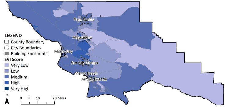
Social vulnerability to extreme heat in San Luis Obispo County is spatialized in Figure 4.1. The SVI scores are classified into five natural break classes as described in the methodology, with light purple corresponding to “very low” and dark blue corresponding to “very high” relative vulnerability. Since it is difficult to identify the areas of high vulnerability from Figure 4.1.

Figure 4.8: Area of Medium and High SVI in San Luis Bay Coastal, South County Coastal, and South County Inland Planning Areas.
Figure 4.8 demonstrates the 4.5 RFP EHD scenario overlapped with medium and high SVI scores in San Luis Bay Coastal, South County Coastal, and South County Inland Planning Areas. SVI is high in certain areas of Pismo Beach and Arroyo Grande, and both areas are expected to have a very low relative EHD exposure in the future.
SUMMARY & CONCLUSION
Extreme heat is a natural hazard predicted to increase in frequency, intensity, and duration in future years. This hazard poses significant public health concerns across the nation, as it is the leading cause of weather-related human mortality in the United States and can significantly exacerbate other pre-existing health concerns. In addition, social characteristics put certain populations at disproportionate risk to extreme heat, calling to attention the concept of social vulnerability.
This project assesses San Luis Obispo County’s social vulnerability to extreme heat by collecting block-level data of social vulnerability, generating an SVI score with SPSS software, and spatializing with GIS the resulting SVI values compared to a conservative future scenario of extreme heat (RCP 4.5). According to geospatial analysis, there are varying levels of social vulnerability to extreme heat in SLO County. See Section IV and Table 4 of this document for more detail on overlapping areas of relative medium, high, and very high social vulnerability in comparison to extreme heat exposure.
Although there are various efforts in the State and County to address extreme heat, none specifically assess or prepare for vulnerable populations in SLO County. This assessment can help visualize the spatial variation of extreme heat, guide future research, and support efforts in the County to improve emergency response and increase adaptive capacity in specific areas of need. As climate change is predicted to disproportionately harm those most vulnerable, these efforts notably allow stakeholders in San Luis Obispo County to mitigate harm to those whom have fewer resources or lack the capacity to resist the adverse health implications of extreme heat.
Source: California Polytechnic State University
Authors: Julia Isabella Cannata
